Maryland Environmental Service can work closely with stakeholders, offering a grassroots approach to support partners’ needs.
The MES GeoSpatial Team supports the development and implementation of outreach programs including website development, GIS-based web application development, analyses, and mapping support.
Services include:
- Custom application development
- Technology integration
- Custom data integration
- Data management
- QA/QC procedures
- Field support
- Data delivery
- Training
- Outreach
For more information, please contact gis@menv.com.
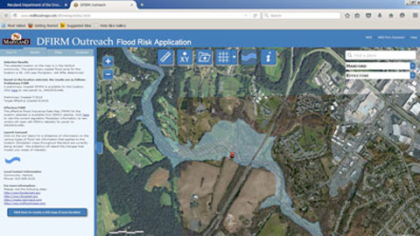
Featured Project: Resiliency Partnership
MES worked directly with citizens to assess their flood risk on a case-by-case basis. For more information, visit www.mdfloodmaps.com.